파일:Physical Map of Europe.jpg
최대 해상도입니다.
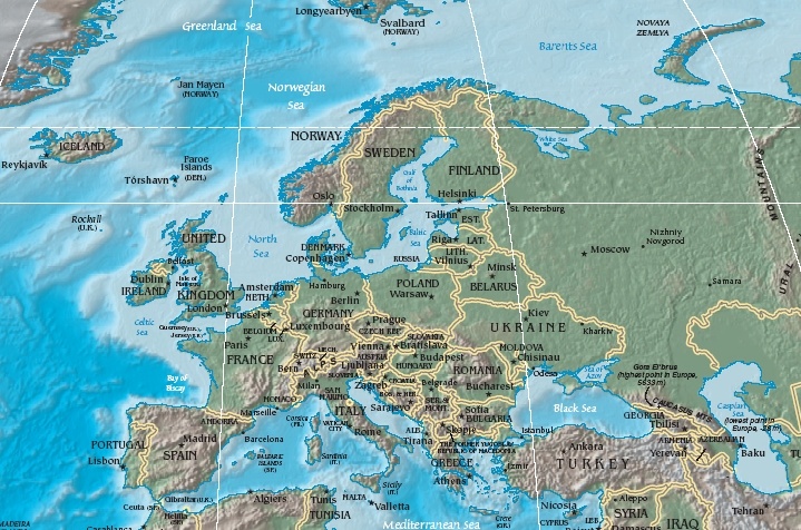
Physical_Map_of_Europe.jpg (719 × 476 픽셀, 파일 크기: 185 KB, MIME 종류: image/jpeg)
- Extended map (enlarged labels): Image:Europe_terrain_CIA_map_extended.jpg.
파일 설명
| 설명 | Terrain map of Europe, as cropping from the CIA's Physical Map of the World. |
| 날짜 | Map dated April 2008 |
| 출처 |
Cropped section from the CIA's Physical Map of the World, formerly available at: but moved to webpage (March 2009): Those webpage URLs require secure-post ("https"), for access, because those pages are encrypted. The larger image this one was cropped from may or may not still be available. |
| 저자 | work of U.S. CIA |
| 다른 버전 |
Same map in expanded form (more labels):
|
라이선스
|
|
 |
파일 역사
날짜/시간 링크를 클릭하면 해당 시간의 파일을 볼 수 있습니다.
| 날짜/시간 | 섬네일 | 크기 | 사용자 | 설명 | |
|---|---|---|---|---|---|
| 현재 | 2005년 10월 19일 (수) 20:56 | | 719 × 476 (185 KB) | Grillo | Physical map of Europe. Cropped from http://cia.gov/cia/publications/factbook/reference_maps/pdf/physical_world.pdf and converted to JPG. From en:Image:Physical Map of Europe.jpg {{PD-USGov-CIA-WF}} |
이 파일을 사용하는 문서
다음 문서 1개가 이 파일을 사용하고 있습니다:
이 파일을 사용하고 있는 모든 위키의 문서 목록
다음 위키에서 이 파일을 사용하고 있습니다:
- as.wikipedia.org에서 이 파일을 사용하고 있는 문서 목록
- bat-smg.wikipedia.org에서 이 파일을 사용하고 있는 문서 목록
- bg.wiktionary.org에서 이 파일을 사용하고 있는 문서 목록
- cy.wikipedia.org에서 이 파일을 사용하고 있는 문서 목록
- da.wikipedia.org에서 이 파일을 사용하고 있는 문서 목록
- Sveriges geografi
- Norges geografi
- Danmarks geografi
- Frankrigs geografi
- Irlands geografi
- Liechtensteins geografi
- Tysklands geografi
- Østrigs geografi
- Europas geografi
- Slovakiets geografi
- Monacos geografi
- Tjekkiets geografi
- Sloveniens geografi
- Storbritanniens geografi
- Tyrkiets geografi
- Schweiz' geografi
- Skabelon:Europas geografi
- Hollands geografi
- Ukraines geografi
- Grækenlands geografi
- de.wikipedia.org에서 이 파일을 사용하고 있는 문서 목록
- el.wikipedia.org에서 이 파일을 사용하고 있는 문서 목록
- en.wikipedia.org에서 이 파일을 사용하고 있는 문서 목록
- es.wikipedia.org에서 이 파일을 사용하고 있는 문서 목록
- es.wikibooks.org에서 이 파일을 사용하고 있는 문서 목록
- fr.wikipedia.org에서 이 파일을 사용하고 있는 문서 목록
- id.wikipedia.org에서 이 파일을 사용하고 있는 문서 목록
- it.wikipedia.org에서 이 파일을 사용하고 있는 문서 목록
- ky.wikipedia.org에서 이 파일을 사용하고 있는 문서 목록
- lrc.wikipedia.org에서 이 파일을 사용하고 있는 문서 목록
- map-bms.wikipedia.org에서 이 파일을 사용하고 있는 문서 목록
- mk.wikipedia.org에서 이 파일을 사용하고 있는 문서 목록
- ml.wikipedia.org에서 이 파일을 사용하고 있는 문서 목록
이 파일의 더 많은 사용 내역을 봅니다.